Kidron River: history, geography, and biblical meaning
Kidron River: history, geography, and biblical meaning
Are you trying to picture where the Kidron River is in relation to Jerusalem’s Old City, the Mount of Olives, and the places described in the Bible? The name can be slightly misleading: the Kidron is usually a seasonal stream channel, not a continuously flowing river. Its valley has shaped Jerusalem’s geography, religious history, burial traditions, and water drainage for thousands of years.
Known in Hebrew as Nahal Kidron, the watercourse runs along the eastern side of Jerusalem. It separates the Old City and the Temple Mount from the Mount of Olives, then turns south and east through the Judean wilderness. Farther downstream, it is commonly known in Arabic as Wadi an-Nar, or “Valley of Fire,” and continues toward the Dead Sea.
For visitors, the Kidron is both a physical landmark and a way to understand the biblical city. It helps explain why ancient travelers crossed east from Jerusalem, why the Mount of Olives was associated with burial and expectation, and why several important biblical stories are connected with its banks.
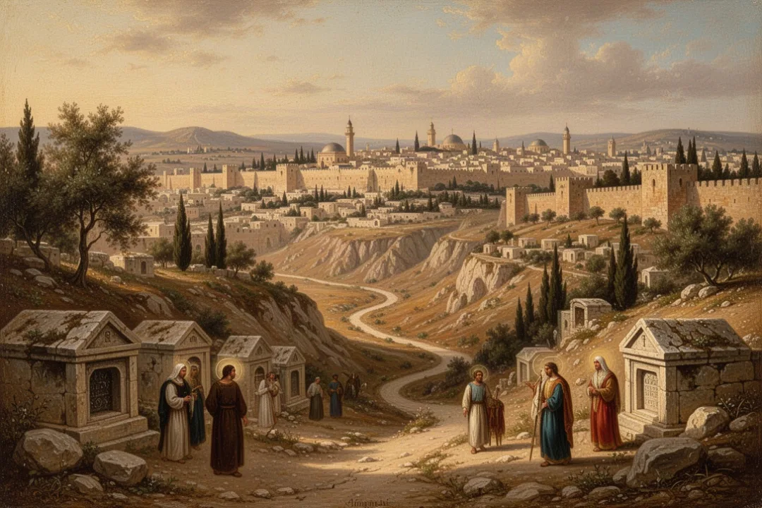
The Kidron Valley lies between two of Jerusalem’s most recognizable landmarks. On the west side are the Old City walls, the Temple Mount, and the City of David. On the east side rises the Mount of Olives, a ridge with churches, cemeteries, villages, and broad views toward the Old City.
The stream channel begins in the area north of the Old City and follows a long depression east of the historic city center. In Jerusalem, its course is not always easy to identify as a river because the channel is often dry during the summer. Rainstorms can send water through it during the wetter winter months, sometimes rapidly and with considerable force.
South of the Old City, the valley bends around the City of David and continues toward the wilderness. This change in direction matters when reading biblical geography. A person leaving Jerusalem through an eastern gate might descend into the Kidron Valley before climbing the Mount of Olives or continuing toward the desert.
West of the valley: the Old City, Temple Mount, and City of David.
East of the valley: the Mount of Olives and its ancient burial grounds.
South and east of Jerusalem: the channel descends through increasingly dry, rugged terrain.
Farther downstream: the watercourse is widely associated with Wadi an-Nar and the route toward the Dead Sea.
The valley’s depth and shape have changed over time because of erosion, construction, roads, retaining walls, and the accumulation of soil and debris. Ancient references do not always describe precisely the same visible landscape that a visitor sees today. The broad geographic relationship, however, remains clear: the Kidron formed Jerusalem’s eastern boundary and created a natural passage below the city.
Geography in one sentence: The Kidron is a mostly seasonal watercourse that runs between Jerusalem’s Old City and the Mount of Olives before descending through the wilderness toward the Dead Sea.
Why the Kidron is called a river even when it is dry
Modern readers may expect a river to contain water throughout the year. The Kidron does not usually fit that image. It is better understood as a seasonal stream or valley watercourse, fed primarily by rainfall and surface runoff rather than by a large permanent spring.
Jerusalem has a Mediterranean climate, with most of its rain falling during the cooler months. In dry periods, the channel may appear as a stony or developed valley with little or no visible water. After heavy rain, runoff from the surrounding slopes can collect quickly, producing a temporary flow. In a narrow or steep section, even a short storm can make the stream hazardous to cross.
The biblical word commonly translated as Kidron may be connected with a Hebrew root associated with darkness, cloudiness, or gloom, although the exact linguistic explanation is discussed by scholars. The name may reflect the shadowed character of the valley, its dark ravines, or the appearance of water carrying sediment. Names in ancient texts often preserve an impression of a place rather than provide a modern scientific description.
Urban development has also affected the watercourse. Roads, walls, homes, drainage systems, and archaeological work have altered how rainwater moves through parts of the valley. Some sections have experienced problems connected with stormwater, sewage, and waste, particularly where modern infrastructure and historic drainage systems meet. Conditions vary by location and can change as authorities carry out repairs or conservation work.
If you visit the valley, treat it as a real drainage channel rather than an ordinary walking path. Avoid entering narrow sections during rain, and do not assume a dry channel will remain safe if weather changes upstream. Flash flooding can occur in desert and semi-desert valleys even when the immediate sky appears clear.
Check the weather before walking in or near the valley.
Stay away from low channels during heavy rain or storm warnings.
Wear sturdy shoes because paths may be uneven, rocky, or slippery.
Follow posted access rules around archaeological sites, cemeteries, and religious properties.
Use current local guidance rather than relying only on an old map or travel description.
What the Kidron means in the Hebrew Bible
The Kidron appears in several biblical accounts because it was a natural route immediately outside Jerusalem. One of the clearest references occurs in the story of David fleeing Jerusalem during Absalom’s rebellion. According to 2 Samuel 15, David crosses the Kidron Valley with his followers before going toward the wilderness. The crossing signals departure from the city and the beginning of a difficult journey away from the royal center.
The valley also appears in accounts of religious reform. In 1 Kings 15:13 and 2 Chronicles 15:16, Asa is described as removing an object associated with his grandmother’s worship and destroying it near the Kidron. The location becomes a place where items connected with unacceptable worship are removed from the city’s religious life.
Other reform narratives use the same setting. During the reforms associated with King Hezekiah, material connected with impurity is carried away to the Kidron Valley, as described in 2 Chronicles 29. Later, in the account of King Josiah’s reforms, objects associated with idolatrous worship are taken out of the temple area and destroyed or disposed of in the Kidron Valley, especially in 2 Kings 23 and related passages.
These stories give the Kidron a repeated symbolic role. It is not simply a geographic depression outside Jerusalem. In the biblical narratives, the valley can function as a boundary between the city and the wilderness, a route of escape, or a place where religious objects are removed. The physical act of carrying something down and away from the temple or city reinforces the idea of cleansing.
The Kidron is also connected with royal movement and mourning. When David leaves Jerusalem, the crossing reflects political crisis and personal grief. In another passage, David’s ascent of the Mount of Olives is linked with sorrow, while the Kidron lies below the route. The valley therefore belongs to a landscape of kingship, exile, reform, and lament.
In the biblical accounts, the Kidron is more than a boundary: it is a route that links Jerusalem with the wilderness and a setting for removal, mourning, and change.
References to the “brook” or “valley” of Kidron should not be read as proof of a broad, permanent river. Biblical writers often use the name for the geographical valley and streambed, whether or not water was flowing at that moment. Translation choices vary, with some versions saying Kidron Valley and others referring to the brook of Kidron.
How the Kidron relates to Jesus and the New Testament
The Kidron appears in the opening scene of John 18. After the Last Supper, Jesus goes with his disciples to a place across the Kidron Valley, where there was a garden. The passage identifies the setting as a route across the valley and then describes Jesus’ arrest there.
The Gospel of John does not name the garden as Gethsemane in that verse, although the other Gospel accounts place Jesus’ prayer and arrest in Gethsemane. The traditional location of Gethsemane lies at the foot of the Mount of Olives, near the Kidron Valley. Visitors should distinguish between the biblical text, later tradition, and the precise identification of modern sites.
The journey across the Kidron would have been geographically natural. From Jerusalem, a person could descend from the city’s eastern side, cross the valley, and reach the lower slopes of the Mount of Olives. The route was close enough to the city to be familiar, yet the gardens and slopes outside the walls offered a quieter place for gathering.
The setting carries strong Christian meaning because the crossing comes immediately before Jesus’ arrest. Readers often see a deliberate contrast with earlier biblical stories: David crosses the Kidron while fleeing a rebellion, while Jesus crosses it on the way to face arrest. The Gospel does not spell out every comparison, but the shared geography invites readers to notice the connection between Jerusalem, the valley, and a decisive moment of suffering.
Several Christian sites near the valley preserve this memory in different ways. The Church of All Nations stands near the traditional Garden of Gethsemane, while the Mount of Olives contains other churches and places of pilgrimage. The exact appearance of the landscape in the first century cannot be reconstructed with complete certainty, especially because centuries of construction, cultivation, erosion, and urban growth have changed the area.
When discussing the New Testament setting, it helps to keep three levels separate:
The biblical location: Jesus went across the Kidron Valley to a garden.
The traditional location: Gethsemane is associated with a garden near the Mount of Olives.
The modern visitor experience: streets, walls, churches, trees, and archaeological areas now occupy parts of the historic landscape.
This distinction does not make the site less meaningful. It gives you a more accurate way to understand pilgrimage: traditions preserve the memory of places, while archaeology and historical geography ask how those places developed over time.
What to see near the Kidron Valley today
The most recognizable section of the Kidron lies between the Old City and the Mount of Olives. From several viewpoints, you can see the valley floor, the eastern walls of Jerusalem, and the extensive cemetery on the Mount of Olives. The landscape combines ancient tombs, religious buildings, archaeological remains, and modern roads.
At the southern end of the Old City, the valley passes beside the City of David, an archaeological area associated with the earliest settled core of Jerusalem. Excavations and visitor routes reveal parts of the ancient city’s water systems, fortifications, and built environment. The exact relationship between ancient streets and the present valley should be interpreted carefully because the terrain has been modified repeatedly.
The lower eastern side of the Old City is especially associated with monumental tombs carved into the rock. These include structures traditionally identified as Absalom’s Tomb, the Tomb of the Sons of Hezir, and the Tomb of Zechariah. Traditional names connect them with figures or groups from the Bible, but the monuments’ actual dates and identities are matters for historical and archaeological study. A traditional label does not automatically prove who built or used a tomb.
The Mount of Olives cemetery extends along the slopes above the valley. Jewish burial has taken place there for many centuries, and the site has profound religious significance. Its importance is connected with Jerusalem, biblical expectation, and the belief held in Jewish tradition that the Mount of Olives has a special place in future redemption. The cemetery is also historically complex, with periods of damage, restricted access, and restoration.
Christian visitors often combine the Kidron Valley with the Garden of Gethsemane, the Church of All Nations, the Church of Dominus Flevit, and the summit area of the Mount of Olives. Muslim heritage is also part of the landscape, including sites and communities associated with the eastern side of Jerusalem. The valley should therefore be understood as a shared sacred landscape, not as a site belonging to only one tradition.
Walking conditions can be demanding. Some routes involve steep inclines, uneven paving, exposed sun, traffic, or limited shade. A practical visit usually works better when you allow time for the Old City, the valley, and the Mount of Olives separately rather than trying to rush through every site in one walk.
For respectful sightseeing: Wear modest clothing near religious sites, ask before photographing people or ceremonies, remain outside marked archaeological areas, and remember that cemeteries are active sacred spaces rather than ordinary tourist stops.
How to interpret the Kidron’s religious and historical importance
The Kidron matters because several kinds of history overlap in one narrow landscape. Its physical form explains movement around Jerusalem, while biblical stories give that movement political and spiritual meaning. Later Jewish and Christian traditions then add layers of burial, pilgrimage, worship, and expectation.
For Jewish readers, the valley is connected with biblical kings, religious reforms, the eastern boundary of Jerusalem, and the cemetery on the Mount of Olives. For Christians, it is associated with Jesus’ movement from Jerusalem toward the garden where he was arrested. For historians and archaeologists, it is a changing urban edge that preserves evidence of burial practices, water management, settlement, and religious memory.
The Kidron also illustrates why place names in sacred texts should be studied geographically. A short reference to crossing a valley can reveal a great deal about a story’s setting. David’s route takes him out of Jerusalem toward the wilderness. Jesus’ route takes him from the city toward a garden on the Mount of Olives. Reformers carry objects downward and away from the temple precincts. In each case, the valley’s position helps the reader understand the action.
At the same time, the name should not be treated as a guarantee that every later tradition identifies an exact original spot. The Kidron Valley itself is a stable geographic feature, but individual tombs, gardens, paths, and buildings may have more uncertain histories. Good interpretation keeps the biblical text, local tradition, and archaeological evidence in conversation without treating them as identical.
If you want a concise answer to the question “What is the Kidron River?” it is this: the Kidron is a mostly dry, rain-fed stream and valley beside Jerusalem’s eastern side. It runs between the Old City and the Mount of Olives, continues toward the Judean wilderness and Dead Sea, and appears in biblical accounts involving David, royal reforms, Jesus, and the sacred landscape around Jerusalem.
Frequently asked questions
Is the Kidron River still flowing today?
Usually, no. The Kidron is primarily a seasonal stream fed by rainfall and runoff. Its channel can remain dry for long periods, especially during Jerusalem’s dry season, but heavy winter storms may produce sudden flows. Urban drainage and development also affect the channel. Anyone visiting should avoid entering low areas during or shortly after heavy rain because flash flooding is possible.
Is the Kidron River the same as the Kidron Valley?
The names refer to closely related features. The Kidron River or brook is the watercourse, while the Kidron Valley is the larger depression through which it runs. English Bible translations use both “Kidron Valley” and “brook of Kidron.” In ordinary conversation, people often use “Kidron” for the entire valley and stream system around Jerusalem.
Can tourists walk through the Kidron Valley?
Some parts can be viewed or reached by established roads and walking routes, especially near the Old City, City of David, Mount of Olives, and traditional tombs. Access varies by site, weather, construction, and security conditions. Wear suitable shoes, follow signs, respect cemetery and religious-site rules, and avoid the channel during storms or flood warnings.
Why is the Kidron important in Christianity?
John 18 places Jesus’ movement across the Kidron Valley before his arrest in a garden. Christian tradition connects that garden with Gethsemane, near the Mount of Olives. The location also has broader significance because crossing the valley represented leaving Jerusalem for the eastern slopes. The site’s importance comes from both the Gospel account and centuries of pilgrimage tradition.











Leave a Reply