7 Churches in Revelation Map: A Visual Guide to Their Locations
The seven churches in Revelation map is more than a simple geographical shell;
it is a layered resource that blends biblical text, historical geography, and the study of ancient routes.
This visual guide aims to help readers and students understand where the churches stood in the landscape
of Asia Minor, how their locations relate to early Christian communities, and what a map can reveal about
the questions addressed in the prophetic letters of the Apostle John.
In Christian tradition, the Revelation map of the seven ecclesiastical communities corresponds to
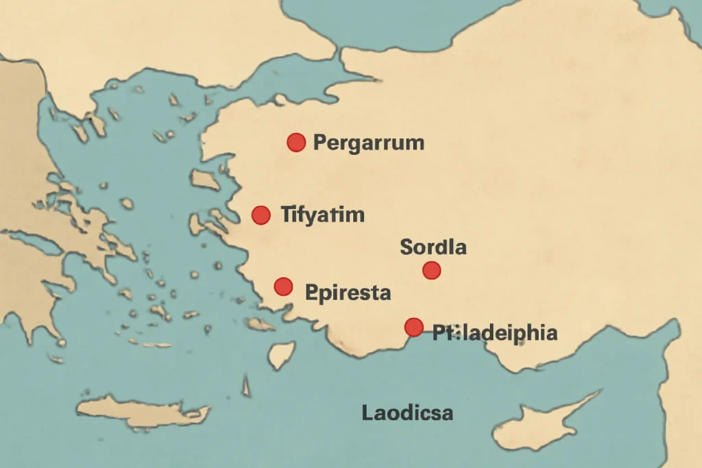
a specific sequence: Ephesus, Smyrna, Pergamum, Thyatira, Sardis, Philadelphia, and Laodicea. On a modern map,
these sites sit within the region known today as western Turkey, along a corridor that connected major Roman
cities and commercial hubs. The study of these sites often goes hand in hand with archaeology, ancient road
networks, and the study of how early Christians organized worship, leadership, and missionary work in a
landscape shaped by politics, trade, and culture.
Overview of the Seven Churches and Their Places in Asia Minor
To begin the journey, it helps to orient yourself with a brief, structured snapshot of each church.
The following short profiles sketch the biblical significance and the geographic setting of each church.
Ephesus — A major port city on the coast, home to a thriving cultural and religious life in antiquity.
The Ephesus site sits near modern Selçuk, not far from Izmir, and its ruins include the famed Library
of Celsus and the Great Theater. This church’s address in Revelation 2 emphasizes perseverance and bearing
up under pressure.
Smyrna — An ancient city that faced pressure and persecution in early Christian memory;
located near present-day Izmir. The letter to Smyrna calls for steadfastness amid trials, and the city’s harbor
and urban layout provide clues to how a Christian community might have functioned in a bustling neighbor of Asia
Minor’s coastal belt.
Pergamum — Known in antiquity for its impressive acropolis and cultural institutions.
The modern site is around Bergama, Turkey. The letter to Pergamum engages readers with themes of compromise
and fidelity amid a sophisticated, polytheistic urban center.
Thyatira — A smaller city with a notable craft economy; modern scholars place Thyatira near
Akhisar. The letter to Thyatira addresses a difficult balance between zeal and moral compromise, using the imagery
of works, love, faith, and endurance.
Sardis — Once a powerful capital of a regional kingdom, Sardis lay along important routes
of commerce; its ruins are near the modern town of Sart, and the site has revealed layered phases of occupation.
The Sardian message warns against spiritual complacency and “dead” works.
Philadelphia — A city that survived through changes in empire and culture; in Revelation,
Philadelphia is praised for its faithful endurance. The modern counterpart lies near Alaşehir. Philadelphia’s message
emphasizes an open door and perseverance under pressure.
Laodicea — A prosperous, fashionable center famous for its wealth and medical schools.
Today’s Laodicea is near Denizli. The Laodicean letter is famous for its admonition about being “lukewarm,”
a reflection on spiritual temperature in a city of luxury and autonomy.
Geography, Modern-Day Sites, and How a Revelation Map Comes to Life
Mapping the Revelation’s seven ecclesiastical sites invites a dialogue between ancient sources
and contemporary geography. The cities mentioned in Revelation were not isolated; they formed a network
of ports, inland towns, and provincial capitals. A visual guide helps readers see how these sites
connected by land and sea translated into the pastoral letters that opened each chapter of Revelation.
Here are some geographic anchors you might consider as you study the map:
Ephesus is a coastal anchor, a hub in Ionia that influenced religious life across the region.
Smyrna sits close to Ephesus, reinforcing the sense of a coastal corridor where early Christians
navigated both urban life and religious pressure.
Pergamum rises inland with a strong plateau presence, illustrating how geography shaped diverse religious
practices in a polis that was both politically and culturally influential.
Thyatira and Sardis sit in relatively fertile inland zones, reflecting a mix of crafts
economies and agricultural production that fueled trade routes through the central Aegean and the interior plateaus.
Philadelphia and Laodicea are placed along routes that encouraged exchange—ideas,
goods, and religious movements—across the western inland regions.
For readers of the Revelation map of the seven churches, understanding the topography—the hills, plains,
river valleys, and coastlines—helps illuminate why certain churches faced particular challenges, what kinds of
infrastructure supported early Christian communities, and how a single letter could be heard across a provincial
landscape with diverse cultures and languages.
The modern-day sites associated with the seven churches in Revelation map are accessible in
Turkey’s Aegean and inland regions. If you visit, you’ll discover ruins, inscriptions, and geographic markers
that bring the ancient letters to life. A map may show distances between Ephesus and Smyrna, or between
Laodicea and Philadelphia, and these distances carry with them a sense of travel time, the possible pace of
ministry, and the logistics of sustaining Christian communities in a pre-modern world.
Illustrative map: The seven churches in Revelation mapped onto western Asia Minor (modern Turkey).
Reading the Revelation Map: Features, Conventions, and What to Look For
A reliable visual guide to the seven churches includes several features that help both scholars and general readers
orient themselves. Below is a practical checklist of map features and conventions you may encounter in a well-made
representation of the Revelation map:
Legend and color coding: Different colors may denote the cities, notable geographical features, or the intended
sequence of the letters in Revelation chapters 2–3.
Geographical relationships: The relative positions of coastal vs. inland cities, and the proximity to major rivers or sea routes.
Scale and distance cues: How far apart the cities are in modern kilometres can illuminate travel possibilities in the ancient world.
Historical overlays: Some maps show ancient road networks, ports, and marketplaces that shaped early Christian life.
Legendary and textual context: A good map connects the textual addresses in Revelation with the historical and archaeological context.
Symbolic layers: In some educational aids, the map may also highlight symbolic motifs connected to each church’s message.
When you engage with the Revelation map of the seven churches, you are not simply locating a set of
towns; you are tracing a living web of early Christian networks. The map becomes a tool for understanding
how a small number of communities shared doctrine, faced external pressures, and responded to challenges in
diverse settings—from port towns to inland markets, from wealth-driven cities to centers of scholarly and artisanal
activity.
A Guided Itinerary: Following the Order of the Letters
The Revelation letters themselves move through a sequence that, in traditional reading, follows the order
of the cities listed in chapters 2 and 3. A map can reflect this order as a circular or linear route, depending
on how a cartographer chooses to present the journey. The following itinerary mirrors the canonical sequence and
offers practical considerations for study or pilgrimage planning:
Ephesus — Start where the story begins in the coastal plain joined to the Aegean world.
Consider how harbor life, local synagogue networks, and a large urbanized setting might inform the church’s strengths
and corrective admonitions in Revelation 2.
Smyrna — Move a short distance to another coastal hub where persecution pressures weighed on the community.
Reflect on resilience in the face of external threats, and how Smyrna’s witness contrasts with the challenges of wealthier cities.
Pergamum — Head inland toward a major plateau center. Pergamum’s religious and political prominence in antiquity
offers a backdrop for the letter’s concerns about compromise with local cults and the need to maintain doctrinal integrity.
Thyatira — Return toward the interior and consider the craft economy and social networks that supported
the church’s mission. Thyatira’s account invites reflection on how Christian communities navigated moral and ethical pressures
in a pluralistic environment.
Sardis — Travel to a city once powerful but now facing spiritual risk of decline. The map in this section helps
readers grasp how a church could lose its vitality while maintaining outward signs of success.
Philadelphia — Move back toward a city with a reputation for endurance under pressure, prompting reflection on
perseverance and the meaning of doors opening in the life of a community.
Laodicea — End at a city noted for wealth and complacency, provoking a meditation on spiritual temperature and the risks
of affluence without faithful praxis.
This itinerary is not a strict travel plan but a framework for engaging with the map’s geography-driven narrative.
It helps readers see how the letters’ concerns relate to the contexts in which the cities stood—economically, politically,
and culturally—encouraging deeper study rather than a superficial glance at the locations alone.
Historical Context and Theological Themes Across the Seven Churches
Reading the Revelation map alongside the letters reveals a set of concrete theological themes that recur
across the seven churches. The map helps illustrate why these themes mattered in different urban contexts. Here are some
concise notes on the core issues each church faced, with the geographic lens in view:
Ephesus — The map helps visualize how a strong, doctrinally robust church could lose its “first love” when
mission and zeal were overshadowed by routine. The coastal setting suggests a dynamic exchange with travelers and merchants,
leading to a robust but potentially complacent worship life.
Smyrna — The city’s history of persecution informs the letter’s call to persevere. The map’s coastal geography highlights
how communication and solidarity with other churches could be mobilized in the face of external pressure.
Pergamum — The larger cultural and political center of Pergamum on the map helps explain the pressure to “hold fast”
in a city known for its religious pluralism and imperial patronage. The geographic prominence translates into a theological emphasis
on fidelity amidst competing claims.
Thyatira — The presence of crafts and trade networks on the map invites reflection on how communities navigated moral
compromises within an urban economy. The map frames the call to avoid “Jezebel” compromises in a context of social influence.
Sardis — The city’s past military and economic power appears in the map as a reminder that outward success can mask spiritual stagnation.
The geography underscores the tension between reputation and vitality.
Philadelphia — The map’s emphasis on location and openness highlights the text’s encouragement to hold fast
and to trust that God has turned what seems impossible into an opportunity for witness.
Laodicea — A prosperous inland center, where the map’s resource-rich setting echoes the letter’s critique of being “lukewarm”
and self-assured. The geographic abundance becomes a foil for the need to pursue real spiritual fervor.
A map-driven study of these themes helps readers see that the Revelation letters were not merely theoretical admonitions but
practical guidance shaped by the everyday realities of life in ancient Asia Minor. The seven churches in Revelation map
thus becomes a bridge between sacred text and geography, inviting ongoing inquiry into how place, community, and message intersect.
Practical Design Tips for an Educational Map of the Seven Churches
If you are a designer, educator, or student creating a map or a map-based lesson about the Revelation map of the seven churches,
here are recommended best practices:
Clear labeling: Use legible font sizes for city names and brief identifiers to avoid clutter in small print areas.
Consistent color system: Assign colors consistently to each church, its letter, and any thematic elements you want to emphasize.
Insets or callouts: For readers unfamiliar with ancient geography, include insets that show the coastal region and the inland
heartland to provide context for travel routes and trade networks.
Photo and artifact integration: Where possible, include photographs or illustrations of ruins, inscriptions, or artifacts
associated with the sites to enrich the learning experience.
Cross-references: Link each site to relevant Revelation chapters (2–3) and to reputable scholarly resources for deeper study.
Accessibility considerations: Provide alt text for images and ensure color contrast meets accessibility standards so that
the map is usable for a broad audience, including readers with visual impairments.
In addition, consider offering alternative map formats, such as a simplified student version for classrooms and a more detailed
scholarly edition for researchers. The seven churches in Revelation map can serve as a dynamic teaching tool when
paired with primary texts and historical sources.
To deepen your understanding of the Revelation’s seven churches and their locations, the following resources offer
reliable historical and textual context. Each link provides access to more details about the cities and their biblical significance.
If you are developing a digital map project, consider incorporating interactive layers that enable users to toggle,
annotate, and compare the biblical text with archaeological finds. A rich, multi-layer map can transform a static image into a
living learning experience, especially for a topic as historically layered as the seven churches in Revelation map.
Conclusion: The Value of a Visual Guide to the Revelation Map
A well-crafted visual guide to the seven churches in Revelation offers more than a simple list of locations. It provides
a framework for understanding how geography, history, and theology intersect in a way that helps readers see the biblical text with
fresh eyes. From the coastal dynamics of Ephesus and Smyrna to the inland civic power of Pergamum,
and from the craft-driven life of Thyatira to the prosperous urban center of Laodicea, the map becomes a
narrative device. It invites readers to ask thoughtful questions about how place shapes belief, how communities respond to pressure,
and how the early Christian witness was expressed across a diverse and connected landscape.
Whether you are a student preparing a seminar, a teacher planning a classroom activity, or a curious reader exploring
biblical geography, this 7 churches in Revelation map serves as a springboard for deeper study. It is an invitation
to move beyond memorization and toward a richer, geography-informed understanding of Revelation’s addresses and their historical
settings. Through this map, you can visualize the journey the letters invite, trace the routes that linked these communities,
and appreciate how a single apostolic message traveled through a region of remarkable cultural and political complexity.








Leave a Reply